
Help Improve This Site
Do you have a correction, suggestion, comment, addition, subtraction?
This page last updated 6/4/2020.
You Are Here: Home > What Do You Want To Do? > Favorite Spring Things
ORIC's Favorite Spring Things to Do
On This Page: Backpacking | Bouldering | Camping | Climbing | Cycling | Events | Fishing | Geocaching | Hiking
Horseback Riding | Hot Springs | Hunting | Orienteering | Paddling | Places to Go | Recreational Trails | Scenic Drives
Spring Skiing | Spring Snow Melt Schedule | Star Gazing | Utah | Waterfalls | Wildflower Viewing | Wildlife Viewing
Spring in the Rockies is a transitional period. High mountain lakes will generally remain frozen until July. North facing slopes hold the snow and ice longer. Spring snow melt can make stream crossings hazardous. Snow melt will depend on whether precipitation was below, at, or above average.
Mud season, on average, begins in April and can run through June. Roads can be treacherous in the mud season. There are closures related to wildlife activity. Flash floods, thunderstorms and lightning, rock slides, temperature swings, ticks, and avalanches are other things to be aware of in the spring.
The Bureau of Land Management has 8 million acres of public land for your to explore in Colorado. Colorado Parks & Wildlife has 42 great parks. So, shake off the winter blues with the following spring activities.
Backpacking
You'll want to stay lower in the Spring if you want a snow-free experience. Otherwise, go equipped for winter camping.
Alamosa Region
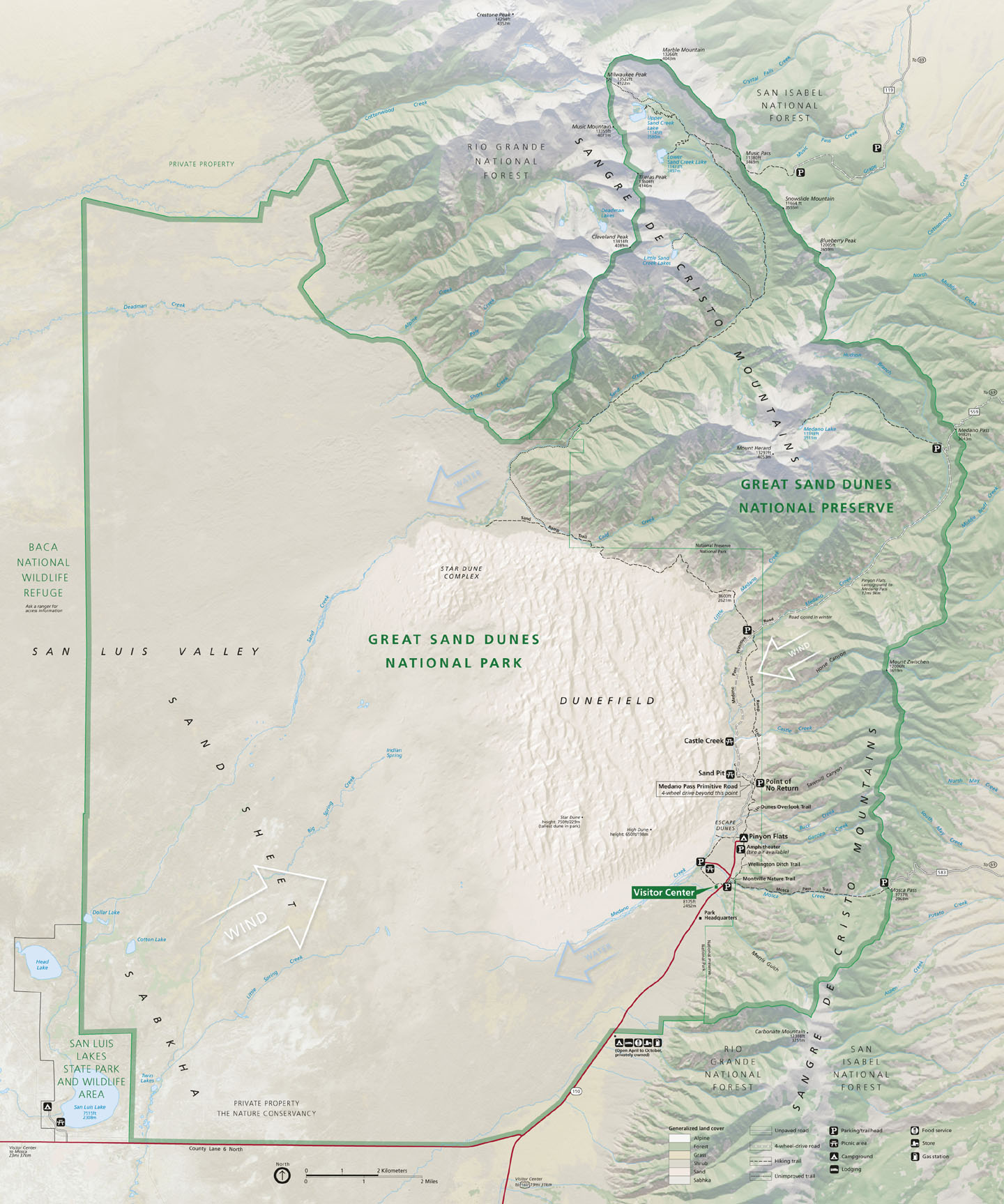
- Great Sand Dunes National Park and Preserve. Open year round. You can hike in to the dunes and camp under the stars. It's a good idea to contact them before you go for current updates. Park map.
Craig Region
- Dinosaur National Monument. May and June are good months to hike in and backpack. Monument map.
Denver Region
- Buffalo Creek Recreation Area. This is a good place to get in some Spring hiking, biking and camping. Call the USFS South Platte Ranger District for trail updates.
- Golden Gate Canyon State Park. Four backcountry shelters and 20 backcountry tent sites. Backcountry permits are required and can be obtained at the Visitor Center. Park backcountry camping brochure.
-
Lost Creek Wilderness. The snowline is generally below 10,000 feet
by Memorial Day weekend and may be accessible earlier.
- Ben Tyler Trail #606. Nice, close-in, overnight backpacking location.This trail climbs, but the lower section should be accessible by Memorial Day weekend. USFS webpage. USFS map. ORIC Trail Map/Description Sheet (4).
- Goose Creek Trail #612 to the Shafthouse. Good hiking and backpacking trail. It may be snow free in April, but more of a sure thing in May. You may run into snow at the upper reaches of this backpacking loop into June. USFS webpage. Full route description: ORIC Trip Map/Description Sheet (Q).
- Wigwam Trail #609 to Wigwam Park. Good hiking and backpacking trail usually accessible by Memorial Day weekend and quite possibly sooner. The trail parallels Wigwam Creek on it's way to Wigwam Park and a series of beaver ponds. USFS webpage. ORIC Trail Map/Description Sheet (35).
- White Ranch Park. (Jefferson County Parks.) 4,391 acres and 18.5 miles of trails. Sawmill Hikers Campground: backcountry campsites, picnic tables and restrooms. Call 303-271-5925 to obtain a free use camping permit.
Eagle Region
- Lower stretches of the Cross Creek Trail #1855 in the Holy Cross Wilderness. Check in with the Holy Cross office of the Eagle-Holy Cross Ranger District, 970-827-5715, for road and trail conditions. USFS webpage. USFS quicksheet. ORIC Trip Map/Description Sheet (M).
Estes Park Region
- Lion Gulch Trail #949. Low enough to get in some hiking and backpacking. USFS webpage. USFS Homestead Meadows quicksheet.
Fort Collins Region
- Greyrock National Recreation Trail #946. Low enough to get in some early season backpacking. USFS webpage. USFS quicksheet. See chapter "9. Greyrock Trail" in Pack Guide: The Best Fort Collins Hikes. See chapter "58. Greyrock Trail" in The Best Front Range Hikes. See chapter "1. Greyrock National Recreation Trail" in Hiking Colorado's Front Range.
- Lory State Park. Good early season place to go backpacking when cabin fever sets in. Backcountry camping by permit on Fridays and Saturdays in April and May. Six backcountry sites, two-mile walk-in, no fires. Park trails webpage. Park trails map.
Grand Junction Region
- Kannah Creek Loop in Grand Mesa National Forest. Accessible from late April into May. Twenty-one mile loop with 3,050 feet elevation gain. Bears are known to frequent the area, but there have been no recorded attacks. It's a good idea to put bear bells on your pack to announce your presence. ORIC Trip Map/Description Sheet (JJ). Area brochure/map.
Montrose Region
- Dominguez & Escalante Canyons. Red rock canyons that are perfect for a Spring adventure. Big Dominguez Canyon is open year round. It's a good idea to call (970-244-3000) for trail conditions, especially in a wet year. It is fairly wide, has several ponds and a waterfall and is known for it's rock art. For something different try Little Dominguez Canyon. It's narrower and a little harder to get through in the growing season, but water is more abundant. BLM brochure and map. ORIC Trip Map/Description Sheet (II).
Bouldering
You'll be able to enjoy this sport earlier in the season if you stay east of the Peak-to-Peak Highway and on south facing slopes. But, be forewarned, bouldering can be extremely dangerous and may result in death. Falls are apparently common. Go with the requisite skills and understand the risks you will be taking. There are many Front Range locations. Here are few resources to help you get started.
- Colorado Bouldering: Front Range. By Phillip Benningfield
and Matt Samet, Sharp End Publishing.
Camping
Most developed campgrounds, including National Forest campgrounds, open around Memorial Day weekend, but there are campgrounds that are either open year round or open before Memorial Day weekend or open later. We will point you to the campgrounds that open earlier or later or stay open year round. We should mention that they may open earlier or later depending on conditions. It's best to phone the ranger district office to confirm the opening date.
It's a good idea to reserve campsites as far in advance as possible and you can make reservations for USFS campgrounds at recreation.gov unless the campground is "first-come, first-served."
Alamosa Region
Boulder Region
- Camp Dick Campground. USFS webpage. USFS campground map. Arapaho/Roosevelt Forests - Boulder Ranger District, 303-541-2500.
- Gross Reservoir, west side. (Dispersed car camping.) Denver Water webpage. The road to the west side of the reservoir does not open until later. Call the Arapaho/Roosevelt Forests - Boulder Ranger District, 303-541-2500, to get road conditions.
- Kelly Dahl Campground. USFS webpage. USFS campground map. Arapaho/Roosevelt Forests - Boulder Ranger District. Sites 1-20 first-come, first-served. Sites 21- 46 can be reserved on recreation.gov.
- Rainbow Lakes Campground. USFS webpage. USFS campground map. Arapaho/Roosevelt Forests - Boulder Ranger District. First-come, first-served.
- West Magnolia. (Dispersed car camping.) USFS trailhead webpage. Arapaho/Roosevelt Forests - Boulder Ranger District, 303-541-2500.
Buena Vista Region
- Angel of Shavano Group Campground. USFS webpage. San Isabel Forest - Salida Ranger District.
- Cascade Campground. USFS webpage. San Isabel Forest - Salida Ranger District.
- Chalk Lake Campground. USFS webpage. San Isabel Forest - Salida Ranger District.
- Collegiate Peaks Campground. USFS webpage. San Isabel Forest - Salida Ranger District.
- Elbert Creek Campground. USFS webpage. San Isabel Forest - Leadville Ranger District.
- Halfmoon East Campground. USFS webpage. San Isabel Forest - Leadville Ranger District. First-come, first-served.
- Monarch Park Campground. USFS webpage. San Isabel Forest - Salida Ranger District.
- Mount Princeton Campground. USFS webpage. San Isabel Forest - Salida Ranger District.
- North Fork Campground. USFS webpage. San Isabel Forest - Salida Ranger District.
- O'Haver Lake Campground. USFS webpage. San Isabel Forest - Salida Ranger District.
-
Turquoise Lake Recreation Area.
- Baby Doe Campground. USFS webpage. San Isabel Forest - Leadville Ranger District.
- Belle of Colorado Campground. USFS webpage. San Isabel Forest - Leadville Ranger District.
- Father Dyer Campground. USFS webpage. San Isabel Forest - Leadville Ranger District.
- Matchless Campground. USFS webpage. San Isabel Forest - Leadville Ranger District. First-come, first-served.
- May Queen Campground. USFS webpage. San Isabel Forest - Leadville Ranger District.
- Molly Brown Campground. USFS webpage. San Isabel Forest - Leadville Ranger District.
- Printerboy Group Campground. USFS webpage. San Isabel Forest - Leadville Ranger District.
- Silver Dollar Campground. USFS webpage. San Isabel Forest - Leadville Ranger District.
- Tabor Campground. USFS webpage. San Isabel Forest - Leadville Ranger District.
-
Twin Lakes Recreation Area.
- Dexter Campground. USFS webpage. San Isabel Forest - Leadville Ranger District. First-come, first-served.
- Lakeview Campground. USFS webpage. San Isabel Forest - Leadville Ranger District.
- Parry Peak Campground. USFS webpage. San Isabel Forest - Leadville Ranger District. First-come, first-served.
- Twin Peaks Campground. USFS webpage. San Isabel Forest - Leadville Ranger District. First-come, first-served.
- White Star Campground. USFS webpage. San Isabel Forest - Leadville Ranger District.
Cañon City Region
- Alvarado Campground. USFS webpage. San Isabel Forest - San Carlos Ranger District.
- Coaldale Campground. USFS webpage. San Isabel Forest - Salida Ranger District. First-come, first-served. Opening date not specified.
- Davenport Campground. USFS webpage. San Isabel Forest - San Carlos Ranger District.
- Hayden Creek Campground. USFS webpage. San Isabel Forest - Salida Ranger District. First-come, first-served. Opening date not specified.
- Lake Creek Campground. USFS webpage. San Isabel Forest - San Carlos Ranger District. First-come, first-served.
- Lake Isabel Recreation Area - La Vista Campground. USFS webpage. San Isabel Forest - San Carlos Ranger District.
-
Lake Isabel Recreation Area.
- Ponderosa Group Campground. USFS webpage. San Isabel Forest - San Carlos Ranger District.
- Southside Campground. USFS webpage. San Isabel Forest - San Carlos Ranger District.
- Spruce Group Campground. USFS webpage. San Isabel Forest - San Carlos Ranger District.
- St. Charles Campground. USFS webpage. San Isabel Forest - San Carlos Ranger District.
- Lake Pueblo State Park. Park camping webpage.
- Oak Creek Campground. USFS webpage. San Isabel Forest - San Carlos Ranger District. First-come, first-served.
- Ophir Creek Campground. USFS webpage. San Isabel Forest - San Carlos Ranger District. First-come, first-served.
- Red Canyon Park. (City of Cañon City.) Free camping. No water. Proximity to Shelf Road rock climbing area. Almost no information on web. Best we could find: Whitewater Adventure Outfitters "Camping" webpage (scroll to bottom).
- Royal Gorge Park. (City of Cañon City.) Open year round. Free camping. No water. 888-333-5597. Separate from the commercial Royal Gorge Bridge & Park. FreeCampsites.net webpage.
Colorado Springs Region
- Colorado Campground. USFS webpage. Pike Forest - Pikes Peak Ranger District.
- Meadow Ridge Campground. USFS webpage. Pike Forest - Pikes Peak Ranger District.
- Mueller State Park. Park camping webpage. This state park has a labyrinth of hiking and biking trails.
- Painted Rocks Campground. USFS webpage. Pike Forest - Pikes Peak Ranger District.
- Pike Community Group Campground. USFS webpage. Pike Forest - Pikes Peak Ranger District.
- Red Rocks Group Campground. USFS webpage. Pike Forest - Pikes Peak Ranger District.
- South Meadows Campground. USFS webpage. Pike Forest - Pikes Peak Ranger District.
- Springdale Campground. USFS webpage. Pike Forest - Pikes Peak Ranger District. First-come, first-served.
- The Crags Campground. USFS webpage. Pike Forest - Pikes Peak Ranger District. First-come, first-served.
- Thunder Ridge Campground. USFS webpage. Pike Forest - Pikes Peak Ranger District.
- Wye Campground. USFS webpage. Pike Forest - Pikes Peak Ranger District. First-come, first-served.
Craig Region
- Dinosaur National Monument. Camping webpage. Check website for opening for the following campgrounds: Split Mountain Campground, Rainbow Park Campground, Echo Park Campground, Gates of Lodore Campground and Deerlodge Park Campground. They will not have water from fall to spring and may be difficult to access due to snow pack and run-off. Green River Campground: first-come, first-served. Call for a condition update.
Denver Region
- Buffalo Campground. Pike Forest - South Platte Ranger District.
- Burning Bear Campground. USFS webpage. Pike Forest - South Platte Ranger District. First-come, first-served.
- Chatfield State Park. Park camping webpage. Metro Denver camping in proximity to Chatfield Reservoir.
- Cherry Creek State Park. Park camping webpage. Metro Denver camping with a variety of activities to keep you entertained.
- Clear Lake Campground. USFS webpage. Arapaho/Roosevelt Forests - Clear Creek Ranger District First-come, first-served.
- Cold Springs Campground. (USFS) Reservations webpage. Arapaho/Roosevelt Forests - Clear Creek Ranger District.
- Columbine Campground. USFS webpage. Arapaho/Roosevelt Forests - Clear Creek Ranger District.
- Dear Creek Campground. USFS webpage. Pike Forest - South Platte Ranger District. First-come, first-served.
- Devils Head Campground. USFS webpage. Pike Forest - South Platte Ranger District. First-come, first-served.
- Echo Lake Campground. USFS webpage. Arapaho/Roosevelt Forests - Clear Creek Ranger District.
- Flat Rocks Campground. USFS webpage. Pike Forest - South Platte Ranger District. First-come, first-served.
- Geneva Park Campground. USFS webpage. Pike Forest - South Platte Ranger District.
- Golden Gate Canyon State Park. Park camping webpage.
- Goose Creek Campground. USFS webpage. Pike Forest - South Platte Ranger District. First-come, first-served.
- Green Mountain Campground. USFS webpage. Pike Forest - South Platte Ranger District. First-come, first-served.
- Guanella Pass Campground. USFS webpage. Arapaho/Roosevelt Forests - Clear Creek Ranger District.
- Hall Valley Campground. USFS webpage. Pike Forest - South Platte Ranger District. First-come, first-served.
- Handcart Campground. USFS webpage. Pike Forest - South Platte Ranger District. First-come, first-served.
- Indian Creek Campground. USFS webpage. Pike Forest - South Platte Ranger District.
- Indian Creek Equestrian Campground. USFS webpage. Pike Forest - South Platte Ranger District.
- Kelsey Campground. USFS webpage. Pike Forest - South Platte Ranger District.
- Kenosha East Campground. USFS webpage. Pike Forest - South Platte Ranger District. First-come, first-served.
- Kenosha Pass Campground. USFS webpage. Pike Forest - South Platte Ranger District.
- Lone Rock Campground. USFS webpage. Pike Forest - South Platte Ranger District. First-come, first-served after Labor Day until Memorial Day.
- Meadows Group Campground. USFS webpage. Pike Forest - South Platte Ranger District.
- Meridian Campground. USFS webpage. Pike Forest - South Platte Ranger District. First-come, first-served.
- Osprey Campground. USFS webpage. Pike Forest - South Platte Ranger District. First-come, firsT-served.
- Ouzel Campground. USFS webpage. Pike Forest - South Platte Ranger District. First-come, first-served.
- Platte River Campground. USFS webpage. Pike Forest - South Platte Ranger District. First-come, first-served.
- Reynolds Park. (Jefferson County Parks.) Camping webpage. Park map.
- Timberline Campground. USFS webpage. Pike Forest - South Platte Ranger District.
- Wellington Lake -- Castle Mountain Recreation. Camping webpage. Commercial, but well worth checking out. 303-838-5496.
- West Chicago Creek Campground. USFS webpage. Arapaho/Roosevelt Forests - Clear Creek Ranger District.
- Whiteside Picnic Area. USFS webpage. Pike Forest - South Platte Ranger District. First-come, first-served.
Durango Region
- Hovenweep National Monument. 970-562-4282 Ext.10. First come, first-served.
- Mesa Verde National
Park.
Camping webpage.
- Morefield Campground.
- Primitive Camp Sites.
Estes Park Region
- Meeker Park Overflow Campground. USFS webpage. USFS campground map. Arapaho/Roosevelt Forests - Boulder Ranger District First-come, first-served.
- Olive Ridge Campground. USFS webpage. USFS campground map. Arapaho/Roosevelt Forests - Boulder Ranger District.
- Rocky Mountain National Park. Camping webpage. Check website for opening dates for the following campgrounds: Moraine Park and Timber Creek Campgrounds and for when the water is turned on.
Fort Collins Region
- Ansel Watrous Campground. USFS webpage. Roosevelt Forest - Canyon Lakes Ranger District.
- Aspen Glen Campground. USFS webpage. Arapaho/Roosevelt Forests - Canyon Lakes Ranger District.
- Bellaire Lake Campground. USFS webpage. Arapaho/Roosevelt Forests - Canyon Lakes Ranger District.
- Big Bend Campground. USFS webpage. Arapaho/Roosevelt Forests - Canyon Lakes Ranger District. First-come, first-served.
- Big South Campground. USFS webpage. Arapaho/Roosevelt Forests - Canyon Lakes Ranger District.
- Browns Park Campground. USFS webpage. Arapaho/Roosevelt Forests - Canyon Lakes Ranger District. First-come, first-served.
- Chambers Lake Campground. USFS webpage. Arapaho/Roosevelt Forests - Canyon Lakes Ranger District. Sites 1, 29, 34, 37, 41, 48 first-come, first-served. The rest can be reserved on recreation.gov.
- Dowdy Lake Campground. USFS webpage. Arapaho/Roosevelt Forests - Canyon Lakes Ranger District.
- Dutch George Flats Campground. USFS webpage. Arapaho/Roosevelt Forests - Canyon Lakes Ranger District.
- Grandview Campground. USFS webpage. Arapaho/Roosevelt Forests - Canyon Lakes Ranger District. First-come, first-served.
- Jacks Gulch Campground. USFS webpage. Arapaho/Roosevelt Forests - Canyon Lakes Ranger District.
- Kelly Flats Campground. USFS webpage. Arapaho/Roosevelt Forests - Canyon Lakes Ranger District.
- Long Draw Campground. USFS webpage. Arapaho/Roosevelt Forests - Canyon Lakes Ranger District. First-come, first-served.
- Lower Narrows Campground. USFS webpage. Arapaho/Roosevelt Forests - Canyon Lakes Ranger District.
- Mountain Park Campground. USFS webpage. Arapaho/Roosevelt Forests - Canyon Lakes Ranger District.
- North Fork Poudre Campground. USFS webpage. Arapaho/Roosevelt Forests - Canyon Lakes Ranger District First-come, first-served.
- Sleeping Elephant Campground. USFS webpage. Arapaho/Roosevelt Forests - Canyon Lakes Ranger District.
- Stove Prairie Campground. USFS webpage. Arapaho/Roosevelt Forests - Canyon Lakes Ranger District.
- Tom Bennett Campground. USFS webpage. Arapaho/Roosevelt Forests - Canyon Lakes Ranger District.
- Tunnel Campground. USFS webpage. Arapaho/Roosevelt Forests - Canyon Lakes Ranger District.
- Upper Narrows Campground. USFS webpage. Arapaho/Roosevelt Forests - Canyon Lakes Ranger District.
- West Lake Campground. USFS webpage. Arapaho/Roosevelt Forests - Canyon Lakes Ranger District.
Grand Junction Region
Gunnison Region
- Curecanti
National Recreation Area.
Camping
webpage.
- Dry Gulch Campground. First-come, first-served.
- Elk Creek Campground. Map. Reservations can be made at recreation.gov
- Gateview Campground. First-come, first-served.
- Lake Fork Campground. Map. Reservations can be made at recreation.gov
- Ponderosa Campground. First-come, first-served.
- Red Creek Campground. First-come, first-served.
- Red Creek Group Campground. Reservations may be made at recreation.gov
- Stevens Creek Campground. Map.
Montrose Region
- Black Canyon of the
Gunnison National Park.
Camping
webpage. Opening dates vary year-to-year depending on snow
conditions.
- North Rim Campground. First-come, first-served.
- South Rim Campground. Map.
- Curecanti
National Recreation Area.
Camping
webpage
- Cimarron Campground. Map. First-come, first-served.
- East Portal Campground. First-come, first-served.
Northeast Plains Region
- Boyd Lake State Park. Park camping webpage. Front Range camping next to a lake.
- St. Vrain State Park. Park camping webpage.
South Park Region
- Blue Mountain Campground. USFS webpage. Pike Forest - South Park Ranger District.
- Buffalo Springs Campground. USFS webpage. Pike Forest - South Park Ranger District.
-
Eleven Mile Canyon Recreation Area.
- Cove Campground.USFS webpage. Pike Forest - South Park Ranger District.
- Riverside Campground. USFS webpage. Pike Forest - South Park Ranger District.
- Spillway Campground. USFS webpage. Pike Forest - South Park Ranger District.
- Eleven Mile State Park. Park camping webpage.
- Fourmile Campground. USFS webpage. Pike Forest - South Park Ranger District. First-come, first-served.
- Happy Meadows Campground. USFS webpage. Pike Forest - South Park Ranger District.
- Horseshoe Campground. USFS webpage. Pike Forest - South Park Ranger District. First-come, first-served.
-
Jefferson Lake Recreation Area.
- Aspen Campground. USFS webpage. Pike Forest - South Park Ranger District.
- Jefferson Creek Campground. USFS webpage. Pike Forest - South Park Ranger District.
- Lodgepole Campground. USFS webpage. Pike Forest - South Park Ranger District.
- Kite Lake Campground. USFS webpage. Pike Forest - South Park Ranger District. First-come, first-served.
- Lost Park Campground. USFS webpage. Pike Forest - South Park Ranger District. First-come, first-served.
- Michigan Creek Campground. USFS webpage. Pike Forest - South Park Ranger District. First-come, first-served.
- Round Mountain Campground. USFS webpage. Pike Forest - South Park Ranger District.
- Selkirk Campground. USFS webpage. Pike Forest - South Park Ranger District. First-come, first-served.
- Springer Gulch Campground. Eleven Mile Canyon Recreation Area. USFS webpage. Pike Forest - South Park Ranger District.
- Spruce Grove Campground. USFS webpage. Pike Forest - South Park Ranger District.
- Tarryall Reservoir State Wildlife Area. (Colorado Parks & Wildlife.) CO Parks & Wildlife webpage. CO Parks & Wildlife map. Seventeen first-come first-served camping sites. It's a good idea to check the condition of Park County Road 77 before you go. The camping area is approximately 16 miles southeast from the town of Jefferson.
- Twin Eagles Campground. USFS webpage. Pike Forest - South Park Ranger District. First-come, first-served.
- Weston Pass Campground. USFS webpage. Pike Forest - South Park Ranger District. First-come, first-served.
Trinidad Region
- Bear Lake Campground. USFS webpage. San Isabel Forest - San Carlos Ranger District. First-come, first-served.
- Blue Lake Campground. USFS webpage. San Isabel Forest - San Carlos Ranger District. First-come, first-served.
- Cordova Pass Campground. USFS webpage. San Isabel Forest - San Carlos Ranger District. First-come, first-served.
- Purgatoire Campground. USFS webpage. San Isabel Forest - San Carlos Ranger District.
Resources
- Best Tent Camping: Colorado. By Kim Lipker and Johnny Molloy. Menasha Ridge Press. 5th Ed.
- Camping Colorado: A Comprehensive Guide to Hundreds of Campgrounds. By Melinda Crow. 2012. FalconGuides.
- Moon Colorado Camping: The Complete Guide to Tent and RV Camping. By Sarah Ryan, 2011. Avalon Travel.
Climbing
Many of these areas are accessible as early as April. But, be forewarned, climbing, in its many variations, can be extremely dangerous and may result in death. Go with the requisite skills and understand the risks you will be taking. There are many Front Range locations. Here are few to help you get started.
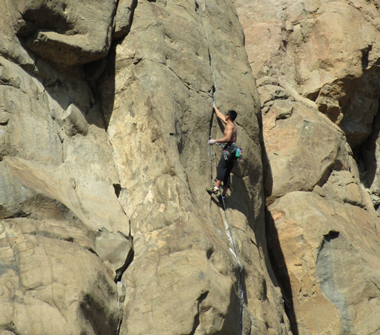
Rock climber on south facing cliff of North Table Mountain at Golden. Photo by Anne & Rob Brumbaugh.
Boulder Region
- Eldorado Canyon State Park. Park rock climbing webpage. Park brochure/climbing routes map.
- Flatirons. (City of Boulder Open Space & Mountain Parks.) CBOSMP website. CBOSMP climbing webpage. CBOSMP current closures webpage. Mountain Project "Flatirons" webpage.
Colorado Springs Region
Denver Region
- Castlewood Canyon State Park. Park activities webpage with rock climbing information. Park brochure/maps.
- Clear Creek Canyon Park. (Jefferson County Parks.) JCP park webpage. JCP climbing brochure.
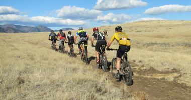
Cycling
Mountain Biking
These are a selection of trails that may be accessible in the spring. It's a good idea to call for trail conditions before you go.
Boulder Region
- Doudy Draw trail system (City of Boulder Open Space and Mountain Parks). CBOS&MP trailhead webpage.
- Hall Ranch trail system. (Boulder County Parks and Open Space.) BCP&OS park webpage. BCP&OS park brochure. BCP&OS trails map. Call for trail conditions.
- Marshall Mesa trail system (City of Boulder Open Space and Mountain Parks). CBOS&MP trailhead webpage.
- Rabbit Mountain trail system. (Boulder County Parks and Open Space.) BCP&OS park webpage. BCP&OS park brochure. BCP&OS trails map.
Denver Region
- Buffalo Creek Recreation Area trail system. Huge network of mountain biking trails. USFS brochure/map. May.
- Centennial Cone Park trail system. (Jefferson County Parks.) JCP park webpage. JCP trails map. Call for trail conditions.
- Colorado Trail (part of Segment 1) at Waterton Canyon. This unpaved trail follows the South Platte River for approximately 6.5 miles to the Strontia Springs Spillway. From here you'll need a mountain bike to go further. Whole segment is 16.8 miles.
- Elk Meadow Park trail system. (Jefferson County Parks.) JCP trails webpage. JCP trails map. Call for trail conditions.
- Lair o' the Bear Park trail system. (Jefferson County Parks.) JCP trails webpage. JCP trails map. Call for trail conditions.
- White Ranch Park trail system. (Jefferson County Parks.) JCP trails webpage. JCP trails map. Call for trail conditions.
- William F. Hayden Park trail system on Green Mountain. (City of Lakewood Parks, Forestry and Open Space.) Park webpage. Park map.
Grand Junction Region
- Book Cliffs trail system at Fruita (Bureau of Land Management. MTB Project webpage. Suggest calling the BLM office in Grand Junction 970-244-3000 for trail conditions.
- Fruita Fat Tire Festival.
- Kokopelli's Trail. (Bureau of Land Management.) Loma, CO, to Moab, UT. May or June. 142-mile multi-use trail. BLM webpage. MTB Project webpage. See description on Latitude 40 Degrees map Fruita / Grand Junction Colorado Trails Recreation Topo Map.
Biking group on Rim Rock Trail on North Table Mountain at Golden. Photo by Anne & Rob Brumbaugh.
Paved Path Cycling
Cañon City Region
- Pueblo River trail system. Late March. City of Pueblo map. Thirty miles of trails.
Denver Region
- Denver B-Cycle bike rental system. Website.
- Denver Bike Path System. Denver Bike Map. Check out Great Road Rides Denver by Jay P. K. Kenney for a pretty comprehensive list of bike paths.
Northeast Plains Region
- Poudre River Trail. Pouder River Trail Corridor website. Map. Twenty-one miles: Greely - Windsor.
Summit County Region
- Blue River RecPath -- Frisco to Breckenridge. 19.76-mile bike path. Summit County RecPath map.
- Ten Mile Canyon National Recreation Trail. June. TrailLink webpage. Summit County RecPath map. USFS webpage. AllTrips Vail Recreation Path webpage. One of several names for all or part of a 22-mile paved trail between Frisco and just east of Vail. Opens in June. Other names for parts: Ten Mile Canyon RecPath, Vail Pass RecPath, Vail Pass / Ten Mile Canyon National Recreation Trail. Other trails and secondary roads at each end can extend this from Keystone to the middle of Vail.
Road Biking
Multiple Regions
- Death Ride Tour. Silverton to Silverton loop via Ouray, Telluride, Dolores, Durango. 232 miles and 16,500 feet elevation gain. Early June.
- Ride the Rockies, Route map. Telluride to Colorado Springs. 513 miles and 20,400 vertical feet gain. Middle of June.
Denver Region
- Castle Rock's Elephant Rock Cycling Festival. Early June. Festival website.
Resources
- Road Biking Colorado -- The Statewide Guide. By Michael Seeberg. 2012. Westcliffe Publishers.
- TrailLink by Rails-to-Trails Conservancy. An excellent source for trails (formerly train right-of-ways) that span all three types of cycling.
Events
Alamosa Region
Participate in one of these open air spring events to build your endurance for the summer season.
- Event Calendar. 365 Alamosa Event Calendar.
Boulder Region
- BolderBOULDER. May 27. 10k run. Website.
Denver Region
- Cherry Creek Sneak. Usually last Sunday in April. Check to be sure. Cherry Creek Mall neighborhood. This is mainly a 10-mile run. They, however, also stage a 5-mile run, 3.1 mile run, 1.5 mile sneak sprint, a Kid's Fun Run and a variety of other events to keep everyone entertained. Website.
- National Get Outdoors Day. Usually June 8. Check first. Annual National Get Outdoors Day.
- Platte River Half Marathon & Buckhorn Exchange Relay. April 7. Website.
Fishing
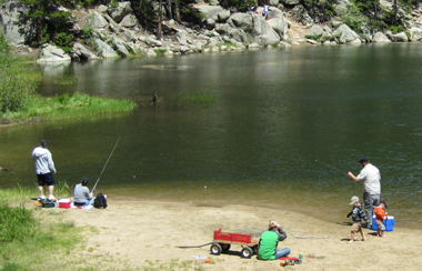
Dude’s Fishing Hole at Golden Gate Canyon Park. Photo by Anne & Rob Brumbaugh.
Unless you're into ice fishing you'll have to wait until ice-off which at lower elevations which occurs sometime in April or May. You'll also need a fishing license to engage in this great pastime. You can get your license online, by phone at 1-800-244-5613, at license agents around the state and at Wildlife Service Centers. The Annual Licenses are valid form April 1 through March 31.
Tail Waters
You can fish tail waters year round. Some recommendations:
- Arkansas River below Pueblo Dam.
- Big Thompson River below Lake Estes.
- Blue River near the Dillon Outlets.
- South Platte River below Cheesman Canyon Dam.
- South Platte River below Strontia Springs Dam.
Lakes, Ponds, Reservoirs
Denver Region
- Aurora Reservoir.
- Barr Lake State Park.
- Bear Creek Lake Park. In Lakewood.
- Chatfield State Park.
- Cherry Creek State Park.
- Quincy Reservoir. In Aurora.
- Rocky Mountain Arsenal National Wildlife Refuge. Seasonal catch and release fishing. The season generally starts mid-April and runs through mid-October.
- South Platte Park, In Littleton. Fishing info and map. Located near the Carson Nature Center in the South Suburban Parks and Recreation District.
- Standley Lake Regional Park. In Westminster.
Eastern Plains Regions
Geocaching
Colorado Geocaching Trails & Maps webpage. A great springtime activity to hone your GPS skills.
Hiking
The key is to stay low in the spring. It's a good idea to call ahead to get trail conditions before you go.
Multiple Regions
- Santa Fe National Historic Trail. Hike or bike.Visit the Santa Fe Trail Association for additional information. The trail spans four states, but a fair amount of it travels through Colorado.
Denver Region
- Castlewood Canyon State Park trail system. Park trails webpage. Park trails map. 303-688-5242.
- Colorado Trail #1776 -- Segment 1. West from Waterton Canyon Trailhead to South Platte Canyon. See description in Colorado Mountain Club Guidebook The Colorado Trail. It's a nice day hike from the Waterton Canyon parking area to the Strontia Springs Dam. Or, if you are so inclined, you can continue hiking the 400+ miles to Durango on the Colorado Trail.
- Devil's Head Fire Lookout Trail #611. USFS webpage. ORIC Trail Map/Description Sheet (12). Pike Forest - South Platte Ranger District.
- Douglas County Open Space Trails. Trail listing. 303-660-7495.
- Golden Gate Canyon State Park trail system. Park trails webpage. Park trails map. 303-582-3707
- Jefferson County Parks Trails.
Park and
trail listing. Park
System Map.
Trail Ratings.
303-271-5925.
- Beaver Brook Trail in Windy Saddle Park. Jefferson County Parks trail map. Clear Creek Land Conservancy webpage.
- Roxborough State Park trail system. Park trails webpage. Park trails map. 303-973-3959.
- South Suburban Parks and Recreation. Trail map. 303-798-5131.
- Staunton State Park Park trails webpage. Park trails map. 303-816-0912.
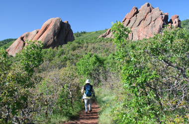
Hiker on lower portion of Carpenter Peak trail in Roxborough State Park. Photo by Anne & Rob Brumbaugh.
Canon City Region
Colorado Springs Region
- Aiken Canyon Trail in Aiken Canyon Natural Area. Colorado Natural Areas webpage. See description "Aiken Preserve Trail" on map Colorado Springs / Pikes Peak (Sky Terrain).
- Cheyenne Mountain State Park Trails System. Park trails webpage. Park trails map. See "Cheyenne Mountain State Park" webpage on Colorado Springs Hiking website. 719-576-2016
- Garden of the Gods. 719-634-6666. Trail map.
- Paint Mines Interpretive Park trail system (El Paso County Parks, Trails & Facilities). EPC park webpage. EPC parkmap. ORIC trail map/description sheet.
Fort Collins Region
- Crow Valley Recreation Area birding trail system. USFS webpage. Trail of the Mourning Dove webpage.
- Pawnee Buttes. USFS trailhead webpage. ORIC trail map/description sheet. See chapter "15. Pawnee Buttes" in Pack Guide: The Best Fort Collins Hikes.
Horseback Riding
You are likely to encounter mud and hazardous stream crossings early in the Spring. Call for trail conditions before you go.
Boulder Region
- Eldorado Canyon State Park trail system. Park trails webpage. Park trails map. 303-494-3943.
Denver Region
- Barr Lake State Park trail system. Park trails webpage. Park trails map. 303-659-6005
- Chatfield State Park trail system. Park trails webpage. Park trails map. 303-791-7275. Chatfield Stables (on site). 303-933-3637.
- Golden Gate Canyon State Park trail system. Park trails webpage. Park trails map. 303-582-3707.
- Indian Creek Equestrian Trail #800. USFS trailhead webpage. USFS map. This trail is numbered 800 on the forest map despite originating at a trailhead numbered 41 on the trailhead webpage above. The USFS may have this trail partly confused with another Indian Creek Trail #41 northwest of this one in the Mount Evans Wilderness.
- Jefferson County
Parks.
Activity Guide showing parks with horses allowed.
- White Ranch Park trail system. JCP trails webpage. JCP trails map. Sourdough Springs Equestrian Campground. JCP campground webpage.
Fort Collins Region
- Lory State Park trail system. Park trails webpage. Park trails map. 970-493-4104.
Resources
- Saddle Up, Colorado! The Statewide Equestrian Trail and Travel Guide. By Sherry and Scott Snead. 2007. Westcliffe Publishers.
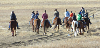
Horseback riders in Chatfield State Park. Photo by Anne & Rob Brumbaugh.
Hot Springs Soaking
These are great anytime of the year, but not all the hike-in hot springs are accessible in the Spring. Here are a few commercial hot springs to get you started.
Buena Vista Region
Steamboat Region
Resources
- Touring Colorado Hot Springs. Susan Joy Paul. 2012. FalconGuides
- Colorado's Hot Springs. Deborah Frazier. 2000. Pruett Publishing,
Hunting
Spring is a great time to plan your fall hunting trip. If you need help deciding where to hunt Colorado Parks & Wildife hunt planners are standing by at 303-291-7526 Monday - Friday 8:00 a.m. - 5:00 p.m. Mountain Time. You can find their full line of hunting brochures online at the Colorado Parks & Wildlife "Regulations Brochures" webpage.
Orienteering
Practice your map and compass skills in the foothills before you head out on your summer backpacking trip. Helpful websites:
- Rocky Mountain Orienteering Club. A great place to hone your orienteering skills.
- Take in one of REI's hands-on Map and Compass or GPS classes. You'll find a schedule of classes at REI Outdoor School Denver Area.
Paddling & Boating
Depending on where you paddle the season may start as early as April and run as late as September. But, generally speaking, the season starts in May and peaks in June.
Buena Vista and Cañon City Regions
- Raft the Arkansas Headwaters Recreation Area. Colorado Parks & Wildlife's "River Outfitters" webpage has links to rafting outfitters. CP&W brochure/map. 719-539-7289.
Gunnison Region
- Morrow Point Boat Tours. Ranger-led tours into the Black Canyon of the Gunnison in the Crrecanti National Recreation Area. Memorial Day weekend through Labor Day. Prepaid reservations required can be made in person at the Elk Creek Visitor Center or by calling 970-641-2337 x205. National Park Service webpage.
Nebraska
- Float the Niobrara National Scenic River. Valentine, NE (north central). National Park Service website has a list of outfitters. NPS map. 402-376-1901.
Resources
- Colorado River Outfitters Association website.
- Colorado Rivers & Creeks. By Gordon Banks and Dave Eckardt. 1999. Paddle Publishing.
- MountainBuzz.com rafting and kyaking website.
- Paddling Colorado: A Guide to the State's Best Paddling Routes. By Dunbar Hardy. 2009. FalconGuides.
Places to Go
Alamosa Region
- Great Sand Dunes National Park & Preserve. National Park Service website. Highest dunes in North America. Camping, hiking, etc. 719-378-6399.
Boulder Region
- Boulder (City of) Open Space and Mountain Parks. CBOS&MP webpage. CBOS&MP interactive trail system map.
- Boulder County Parks and Open Space. BCP&OS trails webpage. BCP&OS open space interactive map.
Central Plains Region
- Sand Creek Massacre National Historic Site. National Park Service website. Check website for hours of operation or call 719-438--5916.
Craig Region
- Canyon Pintado National Historic District Trail System. Attractions: rock art, automobile tours and the East Four Mile walking trail. Bureau of Land Management webpage.
- Dinosaur National Monument. National Park Service website. 435-781-7700.
Colorado Springs Region
- Florissant Fossil Beds National Mounment. National Park Service trails webpage. NPS trails map. 719-748-3253.
- Garden of the Gods Park (Colorado Springs Parks, Trails & Open Space). CS regional parks webpage. Colorado Springs Parks, Trails & Open Spaces. Multiuse park trails maps. See "Garden of the Gods" webpage on Colorado Springs Hiking website. 719-634-6666.
- Paint Mines Interpretive Park. EPC park webpage. EPC parkmap.
- Pike's Peak
- North Slope Recreation Area. City of Colorado Springs webpage. Opens the first of May. 719-385-5940.
- Pike's Peak Cog Railway. 719-685-5401.
Denver Region
- Castlewood Canyon State Park. Park website.
- Golden Gate Canyon State Park. Park website.
- Jefferson County Open Space.
- Red Rocks Park & Amphitheatre. City of Denver website. 720-865-2494.
- Rocky Mountain Arsenal National Wildlife Refuge. US Fish & Wildlife website. 303-289-0232.
- Roxborough State Park. Park website.
Durango Region
- Mesa Verde National Park. National Park Service website. Prehistoric cliff dwellings in the canyon walls. Tours. 970-529-4465.
Estes Park Region
- Hermit Park Open Space. (Larimer County Department of Natural Resources.) LCDNR park webpage. LCDNR park map. LCDNR trails descriptions. Camping (open as early as March). Cabins (can be reserved March - December 19). Hiking and picnicking.
Fort Collins Region
- Cache la Poudre River National Heritage Area. National Park Service website.
- Horsetooth Mountain Open Space. (Larimer County Department of Natural Resources.) LCDNR webpage. LCDNR brochure. LCDNR map.
- Horsetooth Reservoir County Park. (Larimer County Department of Natural Resources.) LCDNR webpage. LCDNR brochure. LCDNR map. Bouldering, camping, cycling, hiking, rock climbing, and water sports.
- Pawnee National Grassland. USFS website. Hike to Pawnee Buttes. Stay at Crow Valley Family Campground. Mountain bike. See Grover Depot Museum. Take self-guided birding auto tour. Pawnee office: 970-346-5000.
- Pine Ridge Natural Area. (City of Fort Collins Natural Areas.) CFCNA webpage. CFCNA Foot Hills Trail Map.
- Reservoir Ridge Natural Area. (City of Fort Collins Natural Areas.) CFCNA webpage. CFCNA Foot Hills Trail Map.
Grand Junction Region
- Bangs Canyon Special Recreation Management Area. Hiking Project webpage. BLM brochure/maps. Cycle the Lunch Loop trail system.
- Colorado National Monument. National Park Service website. Thirty-two square miles of brilliantly colored canyons, mesas, and rock sculptures. Twenty-three mile route for motorists or bicyclists including a loop route and waterfalls. Activities and attractions: camping (developed and backcountry), cycling, hiking, horseback riding, picnicing, and rock climbing. 970-858-3617.
- Grand Junction and Fruita. Great springtime get away: cycling, fruit orchards, paddling, wineries (visit one of more than 13).
- Little Book Cliffs Wilderness Study Area. Bureau of Land Management webpage. Wild horse range map. BLM Coal Canyon trails webpage.
- McInnis Canyons National Conservation Area and Black Ridge Canyon Wilderness. BLM McInnis webpage. BLM Black Ridge webpage. Bureau of Land Management trails webpage. BLM brochure/map. BLM Rabbit Valley webpage.
- North Fruita Desert Special Recreation Management Area. Bureau of Land Management webpage. BLM brochure/map. BLM trails webpage.
Northeast Plains Region
- Cache la Poudre River National Heritage Area. National Park Service website.
Trinidad Region
- Comanche National Grassland.
USFS website.
USFS Motor Vehicle Use Map - East, USFS
Motor Vehicle Use Map - West, USFS
Motor Vehicle Use Map - East - Inset. Here are a few of the many
attractions: Picketwire Canyonlands (below), Carrizo Canyon, Picture
Canyon, Vogel Canyon. Twenty-one non-motorized miles of the Mountain
Route of the Santa Fe trail. Popular activities include mountain
biking, hiking and horseback riding. 719-384-2181. Early spring is
the optimal time to visit.
- Picketwire Canyonlands. Eighteen round-trip miles of non-motorized trails. Guided 4WD tour. Huge set of dinosaur tracks. Withers Canyon. Rock Art. Dolores Mission and Cemetery. Historic Rourke Ranch. USFS brochure. USFS trailhead webpage. USFS guided auto tour webpage.
Recreational Trails
- National Recreation Trails in Colorado. A comprehensive on-line database of Colorado's multi-use recreational trails.
Scenic Driving
Multiple Regions
- Peak-to-Peak Highway. Colorado Department of Transportation webpage. The most scenic way to get to Rocky Mountain National Park from Denver.
- Trail Ridge Road/Beaver Meadow Road in Rocky Mountain National Park. America's Byways webpage. Should be open by Memorial Day weekend.
Denver Region
- Guanella Pass Road. Colorado Department of Transportation webpage. This 22-mile route runs between Georgetown and Grant via Clear Creek County Road 381 and Park County Road 62. It travels the 11,669 foot mountain pass through wildlife and remnants of historic mining operations. Usually opens by Memorial Day weekend
Fort Collins - North Park Regions
- Cache la Poudre-North Park Scenic and Historic Byway. Colorado Department of Transportation webpage. This scenic route connects the historic towns of Ft. Collins and Walden via Colorado State Highway 14. The 101-mile byway goes into Poudre Canyon, over Cameron Pass and into North Park.
Spring Skiing and Snowboarding
For those who just cannot get enough and hate to see the season end.
Denver Region
- Loveland Ski Area. Competes with Arapahoe Basin as the last resort to close for the season.
Summit County Region
- Arapahoe Basin. Competes with Ski Loveland as the last resort to close for the season.
Spring Snow Melt Schedule
This is a rough guide for what to expect in an average year. Revise it accordingly if it is an above or below average snow year. We also recommend checking SNOTEL for current snow depths at monitoring stations throughout the state. Colorado Department of Transportation webcams and 14ers.com can also be good sources for ascertaining the snowline. Users post photos of road conditions to the trailhead and at various points along the trail on 14ers.com. All of these tools should give you a general idea of what to expect.
- 9,500 feet and lower should be dry around mid-May.
- 10,000 feet to 10,500 feet should be dry around mid-June.
- 10,500 feet to 11,500 feet should be dry around July 1st.
- 11,500 feet and above should be dry around mid-July.
Star Gazing
With or without a pair of binoculars. This activity offers you a perfect reason to get away from the city lights. Good locations:
Multiple Regions
- Any of the more than 150 huts, yurts and cabins in ORIC's index.
Denver Region
- Mt. Evans Recreation Area.
USFS webpage.
Scheduled to open Memorial Day Weekend.
Fort Collins Region
- Pawnee National Grassland. USFS website. 970-346-5000
Grand Junction Region
- Colorado National Monument. National Park Service website. 970-858-3617.
Trinidad Region
- Comanche National Grassland. USFS website. 719-384-7647.
Utah
Southeastern Utah's desert playgrounds are close and warm up well before Colorado's higher terrain. Just watch out for the spring winds.
- Arches National Park. National Park Service website. Visitor Guide. Map. You'll beat the heat and the crowds if you go in April. 435-719-2299,
- Canyonlands National Park. National Park Service website. Trip Planner. Map. Both the Needles and Maze Districts are good place to go backpacking. 435-719-2313.
- Capitol Reef National Park. National Park Service website. Trip Planner. 435-425-3791.
- Dead Horse Point State Park. Utah State Parks website. Brochure. 435-259-2614,
- Glen Canyon National Recreation Area/Lake Powell. National Park Service website.
- Goblin Valley State Park. Utah State Parks website. Brochure. 435-275-4584.
- Moab. The Moab Information Center, 800-635-6622, is a great place to start your planning.
- Westwater Canyon of the Colorado River. Bureau of Land Management webpage. BLM river permit webpage. Great paddling.
Waterfalls
Spring snow melt produces magnificent waterfalls.
Woodland Lake Backcountry Zone. Photo by Patrick O'Connor.
Boulder Region
- Boulder Falls. Protrails webpage, trail map.
Denver Region
- Maxwell Falls. USFS Lower Trail #111 webpage. USFS Upper Trail #111 webpage. AllTrails webpage. Excellent loop trail southwest of Evergreen.
Eagle Region
- Bridal Veil Falls at Hanging Lake and Spouting Rock. USFS trail webpage. USFS quicksheet. ORIC Trail Map/Description Sheet (16). This is a plunge type waterfall easily accessible from I-70. It's worth continuing past the lake to a horsetail waterfall aptly named Spouting Rock.
- Rifle Falls State Park. Park map. A segmented waterfall just 100 yards from the trailhead. 970-625-1607.
Estes Park
- Wild Basin in Rocky Mountain National Park. NPS trails map. NPS trails descriptions Numerous falls: Adams Falls, Alberta Falls (photo), Cascade Falls, Copeland Falls, Calypso Falls, Ouzel Falls, Timberline Falls.
Wildflower Viewing
Here are some suggested areas that may be low enough to sport early season wildflowers.
Boulder Region
- Boulder (City of) Open Space and Mountain Parks Trail System. CBOS&MP wildflower guide. CBOS&MP webpage. CBOS&MP interactive trail system map.
Colorado Springs Region
- Florissant Fossil Beds National Mounment Trails System (National Park Service). NPS trails webpage. NPS trails map. Although best known for it's fossil beds and red wood trunks it is also carpeted with wildflowers. The drive getting there is pretty nice too.
Denver Region
- Lost Creek Wilderness.
Forest Service webpage.
- Goose Creek Trail #612. USFS webpage. April through June. Check locally to ensure the trails are open and accessible.
- Wigwam Trail #609 to Wigwam Park and beyond. USFS webpage. ORIC Trail Map/Description Sheet. April through June. Check locally to ensure the trails are open and accessible.
- Mount Falcon Park Trail System (Jefferson County Parks). JCP trails webpage. JCP trails map. The wildflowers in the meadows along the Castle Trail are sensational in May and June. Check locally to ensure the trails are open and accessible.
- Mt. Goliath - Mt. Evans Viewing Area. USFS webpage. Middle of June through the end of July. Check locally to ensure the Viewing Area is open and accessible.
- Reynolds Park Trail System. (Jefferson County Parks.)
JCP trails webpage.
JCP trails map.
- Hummingbird Trail.
- Rocky Mountain Arsenal National Wildlife Refuge. US Fish & Wildlife website. 303-289-0232. Practically a stones throw from Denver.
- Roxborough State Park Trail System.
Park trails webpage.
Park trails map.
- Willow Creek Trail. Day Hikes Near Denver webpage. Early May through June.
- William F. Hayden Park Trail System on Green Mountain. (City of Lakewood Parks, Forestry, and Open Space.) CLPFOS park webpage. CLPFOS map. Great place in the Denver Metro to see early season wildflowers.
Estes Park Region
- Devil's Backbone Open Space trail system (Larimer County
Department of Natural Resources).
LCDNR park webpage, map and trail descriptions.
See chapter "7. Devil's Backbone -- Wild Loop
Trail" in Pack Guide: The Best Fort Collins Hikes.
- Rocky Mountain National Park trail system.
NPS park webpage.
NPS park map.
NPS trails descriptions. Spring is a great time to see the
waterfalls:
- Ouzel Falls via Bluebird Lake Trail. NPS trails map. NPS park map. NPS trail description (under "Water Fall Hikes"). June through August. Check locally to ensure the trail is open and accessible.
Fort Collins Region
- Blue Lake Trail #959. USFS webpage. USFS quicksheet. June through August. Check locally to ensure the trail is open and accessible.
- Cathy Fromme Prairie Natural Area. (City of Fort Collins). CFC webpage. CFC brochure. May through August. Check locally to ensure the Natural Area is open and accessible.
- Horsetooth Mountain Open Space trail system. (Larimer County
Department of Natural Resources.)
LCDNR
webpage, brochure and map.
- Horsetooth Falls Trail - May through July. Check locally to ensure the trail is open and accessible.
- Lory State Park trail system.
Park trails webpage.
Park trails map.
- Arthur’s Rock Trail. Colorado Parks & Wildlife trails webpage. Mid-June. Check locally to ensure the trails are open and accessible.
- Pawnee Buttes. USFS trailhead webpage. ORIC trail map/description sheet. See chapter "15. Pawnee Buttes" in Pack Guide: The Best Fort Collins Hikes. Though a bit of a drive you'll be rewarded with amazing displays of early season prairie wildflowers. You may even decide to stay overnight at the Crow Valley Recreation Area. It's a great place for stargazing. You should also not miss the over 200 species of birds that frequent the Pawnee National Grasslands. And to cap it off you may want to hike to Pawnee Buttes.
Granby Region
- Rocky Mountain National Park trail system.
NPS park webpage.
NPS park map.
NPS trails descriptions. Spring is a great time to see the
waterfalls:
- Adams Falls via East Inlet Trail. NPS trails descriptions. NPS trails brochure/map. It's just a short hike to the falls and you may see Calypso Orchids in the meadows beyond. You may be able to access this area in April and most certainly by May. The trail beyond the meadows, however, gains elevation and may not be accessible until late spring. It, nonetheless,is a good idea to check with Rocky Mountain National Park to ensure the trail is open and accessible.
Grand Junction Region
- McInnis Canyons National Conservation Area Trail System (Bureau
of Land Management).
BLM trails webpage.
BLM brochure/map.
- Rabbit Valley. BLM webpage. Call the Grand Junction Field Office for access and current conditions.
Resources
Wildlife Viewing
Alamosa Region
- Monte Vista Crane Festival. 719-589-4021. Monte Vista National Wildlife Refuge map. - Watch the Sandhill Cranes descend into and lift off from the rye fields. You may see them in late February through the middle of April, but the peak will be in March when the festival is held. So mark your calendar for March 8-10. Visiting the Alamosa National Wildlife Refuge also is recommended while you're in the area. 719-589-4021. Map.
Boulder Region
- Boulder County, Boulder County Audubon Society website. Lists destinations by plains, foothills, and mountains. Bird checklist - 400+ species. 303-678-6200.
Central Plains Region
- Karval Mountain Plover Festival. Karval Community Alliance, Inc. website. Usaully April. Check first.
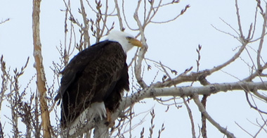
Bald eagle in Addenbrook Park, Lakewood. Photo by Anne & Rob Brumbaugh.
Denver Region
You'd be amazed at the viewing opportunities within an easy drive from Denver.
- Adams County. Colorado Field Ornithologists webpage. eBird Bird Observations
- Douglas County. Colorado Birding Society webpage. Bird checklist
- Jefferson County. Colorado Field Ornithologist webpage: North, Central, South
- Rocky Mountain Arsenal National Wildlife Refuge. US Fish & Wildlife Service website. USFWS map. A 15,000 acre paradise for more than 330 species of wildlife just outside of Denver. This is a must see if you live in or near Denver. It's a family friendly area with a world class visitor center. 303-289-0232.
Northeast Plains Region
- Greater Prairie-Chicken Tours near Wray. Wray Chamber of Commerce webpage.
Trinidad Region
- Lesser Prairie-Chicken viewing area. USFS webpage. Thirty-five miles southeast of Springfield.
Resources